
The group hike
The group stretches out along the trail? The map shows who is where, from first to last. Those waiting at the pass watch the others arrive — no shouting down the valley. Pair it with the trail's itinerary.
YouTim Service
Hike, festival, ski day, road trip: each member chooses to share their position on the group map, for a limited time — and everything stops automatically.
A real-time map with the group's avatars, switched on for a chosen duration, with everyone's consent.
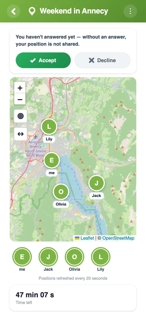
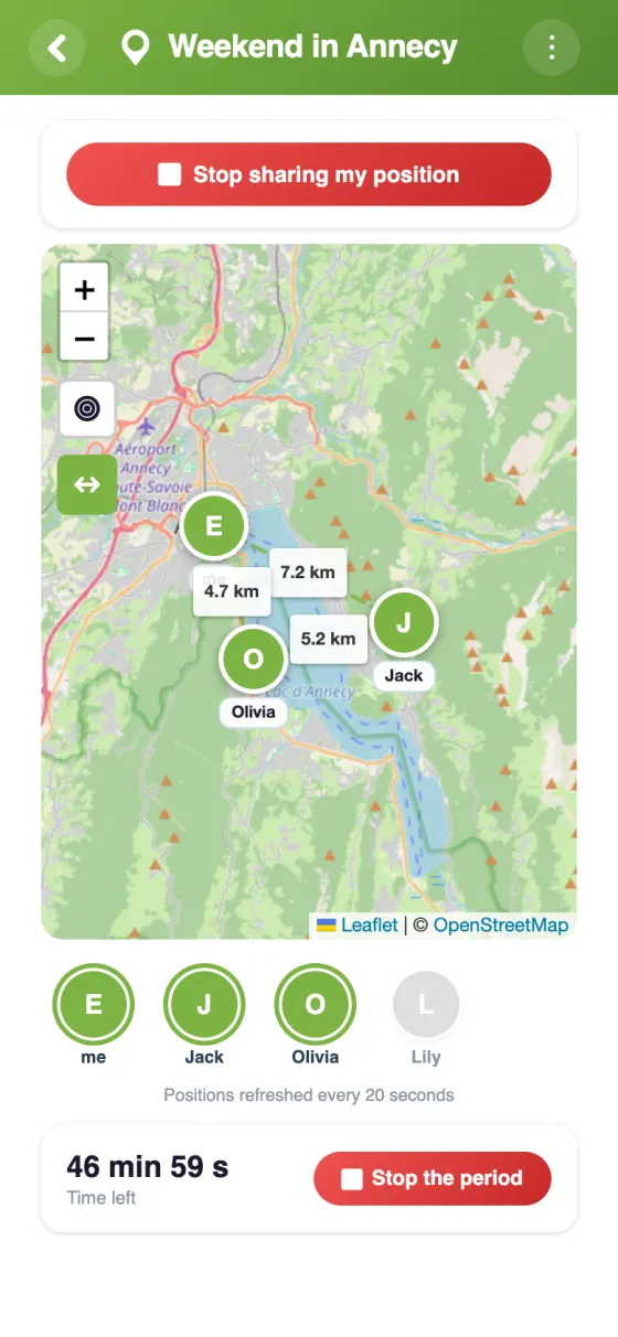
Members' avatars appear on a map that keeps updating throughout the period.
15 minutes, 1, 2, 4 or 8 hours: the sharing duration is set at start — never unlimited.
“Only me”: the others see you on the map with nothing to accept — they just get a notification. “The whole group”: everyone gets a request. Several people can share at the same time.
Precise (every 20 s, accurate to the metre), Normal (every minute, the default) or Battery saver (every 5 min, accurate to about 100 m) to spare your battery over several hours. A position older than a minute shows its age (“2 min ago”).
Nobody is located without agreeing: each member accepts or declines, period by period.
When the period ends, sharing stops by itself. A Stop button also ends it early.
Only the latest position is shown, during the period. YouTim doesn't record the trail of your movements.
Show at a glance the distances between the people visible on the map.
The group is notified when someone shares their location; for a group request, everyone answers in one tap.
The map lives in the same group as the chat, the calendar and the trip itinerary.
How it works
Share only your own location, or request the whole group’s (from 15 min to 8 h): each member accepts or declines to be located. The map shows the people sharing; then sharing stops by itself.

| Feature | YouTim Location | Google Maps | WhatsApp live location |
|---|---|---|---|
| Time-limited with automatic stop | ✓ | or unlimited | ✓ |
| Consent for every period | ✓ | ✗ | per share |
| Whole group on one map | ✓ | 1-to-1 | per conversation |
| No third-party account or phone number | ✓ | Google account | number required |
| Tied to chat, calendar, itinerary | ✓ | ✗ | ✗ |
| Distances between participants | ✓ | ✗ | ✗ |
| GDPR & EU | ✓ | US | US |
Comparison for informational purposes, based on publicly known 2026 features.
The group stretches out along the trail? The map shows who is where, from first to last. Those waiting at the pass watch the others arrive — no shouting down the valley. Pair it with the trail's itinerary.
No more "where are you??" spammed into the chat: everyone sees everyone in the crowd, and the group meets at the right spot between two stages.
A night out downtown, everyone arriving from a different place: the map shows who is already there and who is getting close — no more sending your location every five minutes.
Everyone picks their slope in the morning, everyone meets at the mountain restaurant at noon. The map shows who is still up top and who is already at the table.
Several cars on the holiday route: the map shows how far along each crew is, without texting while driving. The group chat does the rest at the breaks.
City trip, theme park, big market: sub-groups scatter, and the map gets everyone back together in time for the next item on the calendar.
Beach, zoo, flea market: the family scatters as it pleases and regroups without stress — all in the same YouTim as the day's photo gallery.
Yes, completely free, with no in-app purchases and no ads.
When you start, you choose “Only me” or “The whole group”, and a duration of 15 minutes, 1 h, 2 h, 4 h or 8 h. With “Only me”, the others see you on the map and get a simple notification, with nothing to accept. With “The whole group”, everyone gets a request to accept or decline. Any member can share their own location; the admin setting “Participants can request everyone's location” only applies to the group request. Several people can share at the same time, each with their own duration, and only the person sharing can stop their sharing.
No. You accept period by period (or, if you wish, all future requests, in your preferences), and you can stop sharing at any time.
No: YouTim doesn't keep a trail of your movements. For each period, only your latest position is recorded, and it is only shown during the period. It is deleted along with the service or your account.
Yes, with the app, during a period you have accepted: on Android, a notification shows that sharing is in progress; on iPhone, the system's location indicator is displayed. Everything stops automatically at the end of the period. On the web, your position is only shared while the page is open.
Yes: the map is visible only to the YouTim's members, and only during an ongoing period. Your location is encrypted on our servers and deleted at the end of the period. Never sold.
Existing location-sharing tools are designed for permanently following one person (Apple's Find My, Google Maps) or for a conversation (WhatsApp). YouTim Location answers a different need: seeing a whole group on one map, for the length of an activity. Someone starts a period, everyone gives their consent, and at the end it all switches off — nobody has to remember to disable anything.
Hikes, bike rides, ski resorts, festivals, theme parks, big markets: as soon as a group scatters across a large place, the map replaces the calls and the "where are you?" messages. Everyone sees everyone, distances are displayed, and the meeting point becomes obvious.
Location is the most sensitive service a group can share, so YouTim built it with guardrails: short periods (15 minutes to 8 hours), explicit consent period by period, automatic stop at the deadline, a Stop button at any time, and no trail of your movements — only the latest position is shown, only during an active period, only to group members.
The map makes full sense with the itinerary (the planned route on one side, real positions on the other), the calendar (the meeting time), the chat (flagging a delay) and the gallery (the day's photos). A YouTim for an outing is the whole set.
Your positions feed no advertising profile and are never sold. Data stays private to the group, hosted in Europe, GDPR-compliant.
Free, ad-free, in 30 seconds.